The Portile de Fier, or Iron Gates, section of the Danube River has a reputation for hazardous whirlpools, currents and rocks just below the surface. Until the 1970s, passage through this section was limited to 200 or so days of the year when the water level was high enough, and even then experienced captains had to be taken on board. Substantial deepening and widening of sections of the Iron Gates took place in 1896 but the river did not become easily navigable until the 1970s with the construction of the Iron Gates. The Kazan gorge, 10 miles upstream of Orsova, has cliffs which fall 1,968 feet into the Danube. The Romans built a road through the gorge here by drilling holes into the cliff face and inserting beams, which formed the support for a fortified carriageway. A 19th century Hungarian road and the original Roman road have both been lost as a result of Romanian neglect and the eventual rising waters of the Danube. The Iron Gates dam, with its flooding of the Danube as far upstream as Belgrade, has had a massive effect on in-creasing traffic on the river in recent times. The substantial rise in water level following the construction of the dam between 1960 and 1971 made the navigation of the Iron Gates far easier. River traffic passes through a double lock system to descend the 108 feet to the Drobeta side of the dam. There are locks on both the Serbian and the Romanian side of the river.Cazanele Mari and Cazanele Mici represent the final narrowing of the gorge. They are cut in Cretaceous limestone. Cazanele Mari is 650–1000 feet wide, dominated by the steep slopes of the Ciucarul Mare Hill. Here the river has its greatest depth in the gorge (147 feet). The Stirbatu Mic is the narrowest section of the gorge (492 feet).
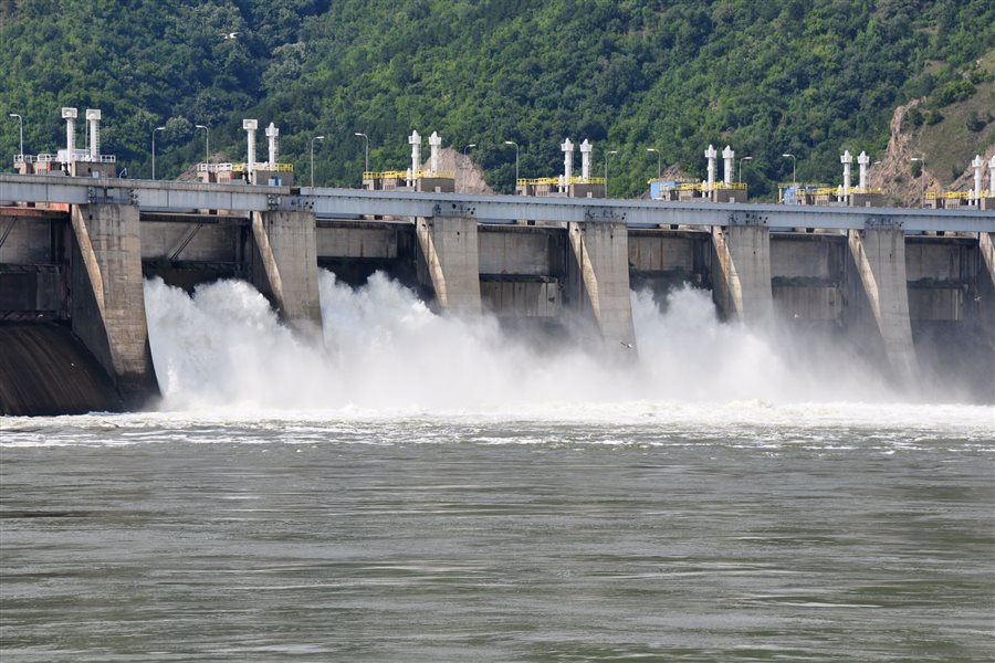 Dam of the Iron Gates (1960-71) was a collosal project but it made the navigation on the Danube much easier and safer.
In 1956, following an agreement between the Yugoslavian and Romanian Governments it was decided to build a hydroelectric plant in the Iron Gates region. The building plan was completed in late 1963. The work on Portile de Fier I (Iron Gates I) Hydroelectric Power Station and Navigation System started in September 1964 and was finished in May 1972. The main part of the system was completed between 1965 and 1970.The place was chosen in order to improve the navigation on the Danube. Due to difficult conditions, the cost and duration of travel was 4–5 times longer than in any other part of the river. The first ship crossed the Canal lock on the left bank on 3 August 1969, and on 14 August 1969 navigation was possible through the Romanian canal lock which was built on one level only. The construction of the Iron Gates greatly influenced the rhythm and manifestation of geomorphologic processes, with consequences on the quality of land and aquatic ecosystems.
The Iron Gates sites which comprise both caves and open-air sites are littered with the debris of centuries of human occupation, including animal remains, bone and stone artifacts, and pottery. The presence of numerous burials sites and domestic artifacts imply that this was an area of permanent or semi-permanent settlements. Some sites, such as Lepenski Vir, appear to have been inhabited continuously during the late Mesolithic and early Neo-lithic age. Since 1989, the British archeologist Clive Bonsall has coordinated the Iron Gates research project, in collaboration with specialists from Great Britain, Hungary, Romania, Serbia and the USA. The research has focused on the period from 7,000 to 5,000 BC during which farming was introduced to the region. Dietary tracing of human remains from Lepenski Vir and Vlasac (sites that are now submerged and no longer available for excavation) provided a new perspective on subsistence practices and their changes through time. Between 1992 and 1996 Clive Bonsall conducted excavations at Schela Cladovei in partnership with Romanian archaeologist Vasile Boronean. This late Mesolithic and early Neolithic site is situated on the Romanian bank of the Danube, about 40 miles down the river from Lepenski Vir.
The Iron Gate project has, of course, had serious environmental impact on the area. Firstly, the raising of the river has caused a marked change to the in-famous and formidable gorge of Kazan section of the Danube, which has been deplored by many who saw the Kazan section as one of the great river gorges of the world. Secondly, the waters have submerged the historically important island of Ada Kaleh and the old town of Orsova and a population of 35,000 inhabitants had to be removed, as well as the system of roads and the railway which were situated along the Danube. Ada Kaleh is supposedly the place where the Argonauts discovered the olive tree and well into the 20th century it was famous for its Muslim community with its own mosques and fortresses. The island remained official Turkish territory until well after the official withdrawal of the Ottoman Empire as a result of a diplomatic oversight. To construct the railway between Drobeta Turnu Severin and Orsova it was necessary to build 56 bridges and viaducts, 100 passageways and 9 tunnels along the 15 mile stretch. A third environmental impact has been the significant slowing of the river‘s flow and the effective backing up of the rivers water. This has caused a number of pollutants moving downstream from the major cities, agricultural areas and, sometimes, war zones upstream. Eutrophic enrichment of the river, primarily by nitrates and phosphates from agricultural fertilizers and from municipal sewerage systems has caused the growth of algae and bacteria, which use up the oxygen in the water. Finally, the flooding of the Danube covered large areas of heavily forested riverside slopes and many of these slopes were not felled prior to the waters rising. This has caused excessive rotting vegetation in the river and con-sequent eutrophication of the river‘s water to add to other pollution problems.
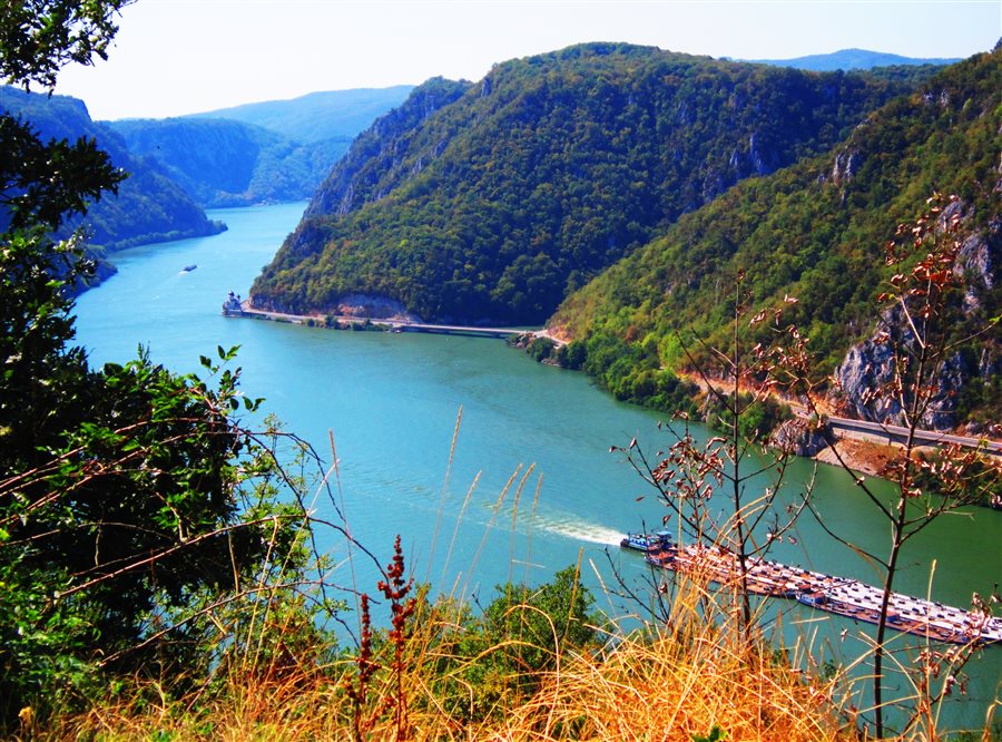 Iron Gates have always evoked respect and fear in the sailors, yet they are one of the most scenic stretches of the whole lower Danube.